Our proprietary methodology
Geospatial engineering for cost segregation
Geospatial Engineering for Cost Seg™
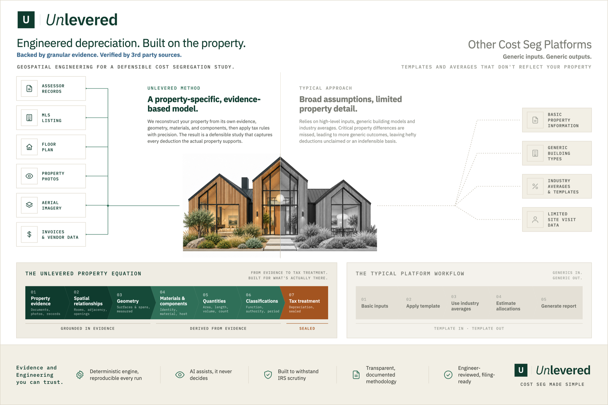
Geospatial engineering is Unlevered's method for cost segregation. We run a reverse takeoff on the specific property, working back from the finished house to every component in it. We map the whole house as a spatial node graph unique to that property, then rebuild it in 3D from measured geometry, with AI vision reading its photographs, floor plans, assessor records, aerial imagery, and invoices. We refine the model until it reconciles, then classify each component for MACRS depreciation and price it from current retail and installed costs, each cited to its source. Every number traces back to the evidence under it, which is what makes the study defensible.
The property equation
Six stages carry a property from its own raw evidence to a sealed, defensible tax treatment. Each stage is derived from the one before it.
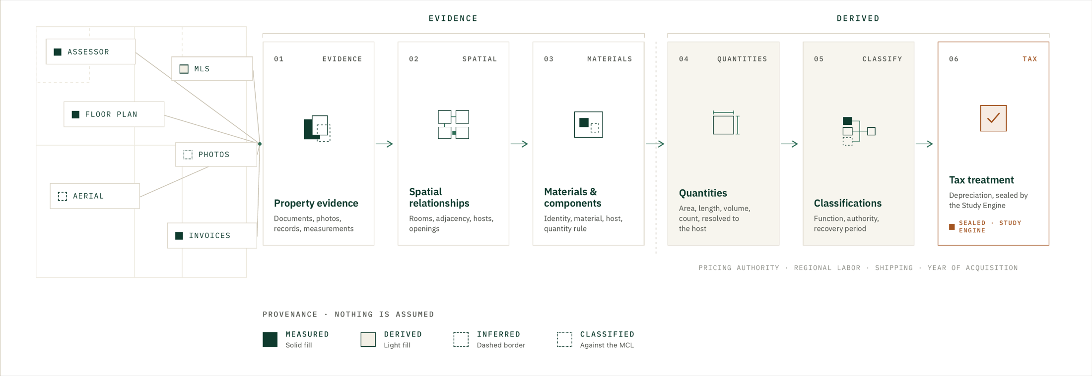
The evidence, the resolved geometry, and the sealed result stay distinct records, so a plausible-looking reconstruction can never quietly become an unsupported tax fact. See how the property equation is solved.
Rigor you can reproduce. Transparency you can trace.
Unlevered is built to be the most rigorous and transparent way to run a cost segregation study, and both claims are things you can check: the calculation is deterministic and reproducible, and every dollar traces back to the evidence under it.
Deterministic, reproducible calculation
The engine produces byte-identical output from the same inputs, enforced in CI by hash replay. The same study calculated twice is the same study. A spreadsheet or a model cannot promise that, and it is the foundation of every audit defense.
Every dollar traces to the evidence
Each material number walks back through a sealed engine run, a component decision, a resolved quantity, a sourced fact, and the original evidence. Nothing appears in the result that cannot be traced to why it is there.
The Workpaper is the proof
A delivered study ships with a line-by-line audit-defense record bound to the same sealed run as the report. An examiner can read it top to bottom and reconcile every figure to a document.
Software decides, AI only reads
AI reads unstructured evidence and proposes; deterministic software calculates; engineering review checks it and a human decides. AI never sets a number and never runs the calculation. The result does not depend on a model's judgment.
More depth: evidence-based cost segregation and how we build a study.
Common questions
- What is geospatial engineering for cost segregation?
- Geospatial engineering is Unlevered's method for cost segregation. We run a reverse takeoff on the specific property, working back from the finished house to every component in it. We map the whole house as a spatial node graph unique to that property, then rebuild it in 3D from measured geometry, with AI vision reading its photographs, floor plans, assessor records, aerial imagery, and invoices. We refine the model until it reconciles, then classify each component for MACRS depreciation and price it from current retail and installed costs, each cited to its source. Every number traces back to the evidence under it, which is what makes the study defensible.
- How is it different from a typical cost segregation study?
- A typical platform starts from generic inputs — a property type, a purchase price, industry averages — and applies a template. Geospatial engineering starts from the actual property: it reconstructs the building from its own evidence, resolves the real geometry and components, and applies the tax rules to what is actually there. Property-specific differences that a template misses become claimed deductions with a documented basis, instead of being averaged away.
- Is a geospatial cost segregation study defensible in an IRS audit?
- It is built to be. Every material dollar traces back through a sealed, reproducible engine run to a resolved quantity, a sourced fact, and the original evidence, and the study ships with a line-by-line audit-defense workpaper an examiner can reconcile. The calculation is deterministic, so the same inputs always produce the same result, and the engineering conclusions are reviewed before delivery.
- Does Unlevered use AI to do the study?
- AI is used only to read unstructured evidence — transcribing a document, proposing candidate rooms or components — and its output is always a proposal. Deterministic software resolves the geometry and calculates the numbers, engineering review checks the result, and a person decides. AI never calculates a financial result and is never required for the study to run.
- What property evidence do you use?
- Whatever the property has: assessor and county records, MLS listings, floor plans, interior and exterior photographs, video walkthroughs, satellite and aerial imagery, renovation documents, contractor invoices and receipts, client-provided facts, and any measurements. Each source is treated as evidence about the same physical structure, and stronger evidence outranks weaker evidence when they disagree.
- Do I still need my CPA?
- Yes. Unlevered prepares and signs the engineering study and delivers filing-ready schedules and documentation. Your CPA reviews it, applies independent judgment, and remains the sole preparer of your return. Unlevered is not a CPA firm and does not file your taxes.
See the method on your property.
Start with one address, or read a real engineered study to see the reconstruction and the reclassification for yourself.